Rumors regarding a highway construction project in the Maya Biosphere Reserve have now been verified. After an investigation in August 2001, ParksWatch – Guatemala has confirmed the existence of a proposal to build three highways through the Maya Biosphere Reserve, the largest and best protected tropical forest in Guatemala. As ParksWatch learned, an assessment was conducted in June 2001 to identify priority corridors for tourism investment in the region (Godoy, 2001). The assessment was done for the Sustainable Development Program of the Mayan World, which is a program of the Inter American Development Bank (IDB). It recommended the construction of three highways that would cross the entire Maya Biosphere Reserve. This would include passing through two core zones: Mirador-Río Azul National Park and Laguna del Tigre National Park (see maps below).
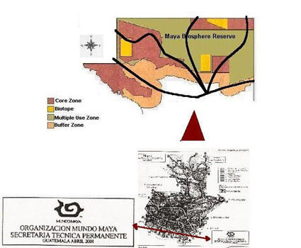
Mundo Maya’s map showing the planned highways through the MBR.
The Mayan World Project
The first Regional Meeting of the Mayan World Project was held in 1988, signifying the beginning of the Project. Representatives from Belize, El Salvador, Guatemala, Honduras and Mexico participated in the meeting. The initial impetus was the need to protect the environment, to protect the cultural and natural heritage through sustainable development, and to involve local communities in tourism (Mayan World, 1993).
There have been efforts to strengthen the Mayan World Project. In 1992, the participating countries signed an agreement to create a Regional Commission, a Managerial Council, and an Executive Secretariat (Ibid). Currently, the main objective of the project is regional development through an increase in tourism. As a result, improvments in the standard of living are expected because of new sources of employment, such as construction and tourism. In March of 2000, the Mayan World Project secured 1.3 million U.S. dollars from the IDB to carry out its objectives (IDB, 2000).
Roads versus Ecosystems
Both Mirador-Rio Azul and Laguna del Tigre National Parks share borders with Mexico; however, the status of these national parks is distinct. Mirador-Rio Azul contains 116,911 hectares and is located in northeastern Guatemala, containing the country’s largest intact forest (Sader, 1999; INAB-CONAP, 2000). Laguna del Tigre contains 289,912 hectares and is located in northwestern Guatemala; it has already lost much of its forest cover due to the expansion of the agricultural frontier (CONAP, 2000).
The National Council of Protected Areas presented research at the beginning of August 2001 demonstrating that the construction of roads in 1986, in the southeastern region of the Maya Biosphere Reserve, caused five kilometers of deforestation along both sides of the roads (see satellite images below). The principal reason was colonization by subsistence farmers.
This research suggests that new construction of roads into Mirador-Río Azul and Laguna del Tigre will most likely increase the risk of deforestation in both areas (CONAP, 2001). Additional threats could be increases in forest fires, illegal hunting and other human activities. The construction of infrastructure inside the national parks is a violation of the Regulation of Protected Areas of Guatemala, which strictly limits any human activity that could harm the essential ecological processes of the protected area (Guatemala, 1989).
ParksWatch obtained a copy of the paper documenting the Mayan World meeting that was held at the beginning of August. Since then, ParksWatch has been disseminating the information so that the public can remain informed about the project. Luckily, the National Council of Protected Areas has given the highways project a skeptical reception after performing an investigation based on satellite imagery of the possible impacts of highways.
Article printed in the Miami Herald:
Plans for Roads through Reserve Met with Alarm.
By Megan Feldman
September 11, 2001
References
IDB, 2000. IDB and Mayan World sign donations for sustainable program in Guatemala, Honduras, El Salvador, Belize and Mexico. Press release.
CONAP, 2000. Status of the Laguna del Tigre National Park. Presentation of the conservation status of the park.
CONAP, 2001. Impacts of highway construction in the Mayan Biosphere Reserve. Preliminary report to be presented to Executive Secretariat of the Presidency.
Godoy, R.., 2001. Los Sac’bes de hoy. Report presented in the XLI meeting of the Directive Council Regional Commission of the Maya World Organization.
Guatemala, 1989. Regulation of Protected Areas of Guatemala.
INAB-CONAP, (2000). Final Report of Forest Fires: 2000 Season. Centro de Operaciones de Emergencia, COE-Petén. Instituto Nacional de Bosques, y Consejo Nacional de Áreas Protegidas.
Mundo Maya, 1993. Maya World Project. In http://www.mundomaya.com
Sader, S. (1999). Deforestation trends in northern Guatemala: a view from space. Pp. 26-30, IN: Thirteen Ways of Looking at a Tropical Forest: Guatemala’s Maya Biosphere Reserve, J.D. Nations (Ed.). Conservation International, Washington, D.C.
(Top image: Above, the top image illustrates a newly opened highway in the buffer zone of the Maya Biosphere Reserve in 1986. The bottom image illustrates that same area (417.5 Km2) just four years later in 1990. The deforestation rate was 1800 Ha/year during that time, resulting in complete loss of forest cover. (Image: NASA))
ParksWatch: August 2001