Megantoni Reserved Zone, Urubamba River, photo ParksWatch-Peru
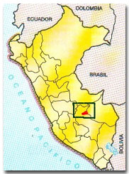
\”The Meganto (1) bird brings happiness to the forest. We see it skimming the waters of Urubamba.\” This description, given by Roger Rivas, leader of the Machigüenga of the Urubamba River Council (COMARU), ends with a clear declaration, \”We should protect our sacred valley.\” And it is what the native Machigüengas like Roger, and five other Amazonian indigenous groups, have been expressing for decades as they face drastic changes with the advance of modern Peruvian society into their territories. Much of the flora y fauna of the Pongo de Mainique Zone (the cultural-geographic formation of the valley) has yet to be discovered by science, but it is already considered threatened because of commercial intentions of new immigrant arrivals to the area. Despite these threats, Ministerial Resolution Number 0234-2004-AG declared 216,005 hectares of the Urubamba River Valley (in the Cuzco Region) as the Megantoni Reserved Zone. Thanks to this declaration, the indigenous communities living there will continue to see the meganto skim the waters of the Urubamba.
Declaring the reserved zone has taken 16 years; it should have been created years ago under a sense of urgency due to its extreme importance. The Megantoni Reserved Zone has been consolidated as an intact corridor between Manu National Park and the protected areas of the Vilcabamba Range. This means that four Peruvian protected areas are directly connected and together protect over 2.7 million hectares (2). According to the results of a Rapid Biological Inventory (RBI) conducted by an international and interdisciplinary team of natural science experts, Megantoni is a pristine area-from the paramo to the lowland forest. The area allows for genetic-population exchanges for species with large habitat ranges. This highlights its important role; it serves as a biological corridor connecting highly diverse protected areas.
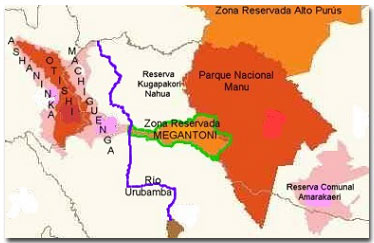
Other protected areas surround Megantoni Reserved Zone. It is part of the Conservation Corridor of the Vilcabamba-Amboro, which includes protected areas in Peru and Bolivia.
The Flyover
Robin Foster, a scientist with the Field Museum of Chicago and member of the expedition to conduct the Executive Summary of the area, best describes Megantoni\’s physical characteristics. He said that the habitat changes drastically and quickly, over a short distance. During the flyover conducted in order to select the study sites for the RPB in November 2003, they passed an intact area that went from lowland rainforest (at 300 meters above sea level) to mountainous plateaus and isolated peaks at 1,000 to 2,000 meters above sea level to summits at more than 4,000 meters. Pongo de Mainique is representative of the area; this valley harbors more than 30 waterfalls. This canyon is formed by the Urubamba River crossing through the Andes, from southwest to northeast. This mythic canyon receives water from the Timpia, Ticumpinia (to the north), and Yoyato (to the south) Rivers, all of which flow through the valleys of the Megantoni Reserved Zone.
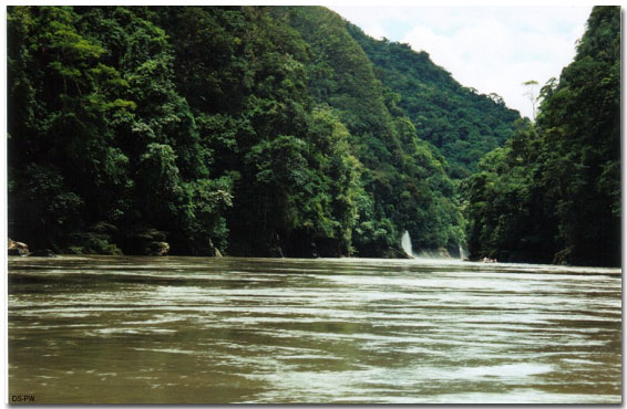
Pongo de Mainique, ParksWatch-Peru
From the air, members of the team noted the contrasting floral biodiversity between the northern and southern portions of the mountains. Floral density varied between high forests and thick understories (dominated by bamboo) and small patches of dwarf forest. A third vegetation type was found in the plateaus-tree ferns covered their steep slopes. However, the most significant find of the trip was the discovery of indigenous groups living in voluntary isolation; they have chosen not to have contact with the outside world.
The Next Step
The interdisciplinary exploration team made up of scientists from the Field Museum of Chicago, the Museum of Natural History of Peru, the Center for Development of Native Inhabitants of the Amazon (CEDIA), the Machigüenga of Urubamba River Council (COMARU), the National Institute of Natural Resources (INRENA), among other Peruvian professionals, traveled to the Megantoni Reserved Zone to conduct the Rapid Biological Inventory. From the air, they identified three areas to establish research sites using the following criteria: likelihood of finding a large number of endemic species. Each site was given a Machigüenga name.
The first was Kapiromashi Site, or \”a lot of bamboo\” and was located at 650-1200 meters above sea level. They set up the camp along one of the largest rivers, the Ticumpinia. Here they found large parcels of bamboo, which grow easily in the loose soil found over limestone rock. The second camp was set up on a higher platform from which they could also study an adjacent one. Both platforms emerge from tributaries of the Ticumpinia. The Machigüenga called this camp \”Katarompanaki, or Clusia, which is a typical plant of the area. Unlike Manu National Park, Megantoni has platforms that reach between 1,200 to 3,000 meters above sea level. The last camp was called Camp Tingkanari after a tree fern and it was located along the border of Manu National Park. Here, the slopes and high mountains and peaks gave way to dozens of ravines. This geology, found at 2,100 to 2,350 meters above sea level, is complex and is a typical mudslide zone.
New Species Discovered
Going into the expedition, the team hypothesized that they would find biological communities that mixed species and elements of the Cordillera de Vilcabamba and Manu National Park (3). They not only found this mixing as predicted, but they also discovered that Megantoni harbors animals and plants not found in the other areas at all. The most amazing aspect of the trip was identifying 120 new species for science and 80 unknown orchid varieties.
During this trip, the scientists registered more than 800 distinct plant species, and they estimate that the entire zone, from the paramo to the lowland forest, harbors between 3,000 and 4,000 plant species in total. Conditions in some areas of the reserved zone seem ideal for specialization. For example, one type of soil or rock in the mountainous area favors development of hyper-diverse families of ferns and orchids, which represented half of all the observed plant species. The forest was dominated by bamboo, but they also identified some small populations of hardwoods such as Cedrela montana and tornillo (Cedrelinga cateniformis).
Scientists inventoried fish, reptiles and amphibians, birds, mammals and dung beetles. According to Max Hidalgo of the Museum of Natural History, the ichthyofauna of the area exceeds 70 species. They registered several fish species that because of their adaptations to the conditions of the zone, such as torrential, cold, clean rivers with high oxygen concentrations, could be endemic and new to science (they are still in the verification process). The herpafauna register included 27 amphibians and 18 reptile species; this shows that the number of herps in Megantoni is similar to that of Manu National Park. Yet, the species themselves diverges somewhat; a third of the species found in Megantoni are not found in surrounding protected areas.
The bird registry also showed local variations, for example, they observed the black tinamou (Tinamus osgoodi), scimitar winged piha (Lipaugus uropygialis), and selva casique (Cacicus koepckeae). All of these are listed as endangered species, according to Birdlife International (4). The ornithologists also identified a high diversity of guans and parrots, although along portions of the expedition there were also signs of poaching. Based on the 378 bird species registered during the expedition, scientists estimate that there are 600 species in the reserved zone.
One of the main reasons to protect Megantoni, however, is neither the high bird diversity nor the incredible herpafuana rather, its diversity of large mammals. The expedition documented 32 large mammals in the zone, five of which are considered threatened and listed on CITES appendix I and 12 listed on appendix II. There were also many footprints and signs of spectacled bear (Tremactos ornatus) populations meaning that this endangered species is thriving in the valley and that they use the area as a migration route.
Socio-cultural Environment
CEDIA along with COMARU collaborated on the expedition in order to conduct the study of human populations within Megantoni. They identified three cultural groups, differentiated by their origins, economic activities, and the way in which they interact with the forest. These groups were the native community, colonists, and uncontacted indigenous groups. While the groups are separate, they have some commonalities: they live in a poorly developed area, they are exposed to disease, there is high infant mortality, and life expectancy is low. There is limited access to basic services and in general, these communities have low quality of life using these measures.
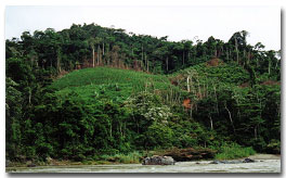
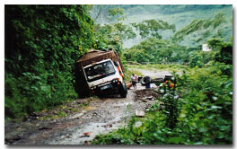
Deforestation by colonists and an expanding road into the reserved zone, photos ParksWatch-Peru
In CEDIA\’s opinion, the native communities are the true managers of the forest. The Machigüengas are the most numerous. According to their traditional customs, they hunt, fish, and collect non-timber forest products; although today because of integration into mainstream society they are complementing these traditional activities with some agricultural activities. The colonists on the other hand moved to the area specifically to develop agricultural activities-focusing on coffee cultivation, cacao, and annatto for commercialization. Their rural settlements near the reserved zone almost guarantee future infrastructure development that will interfere with Megantoni\’s tropical ecosystem. The colonists have degraded the natural resources of the forest, mostly because once their agricultural soils become unfertile, they penetrate further into the forest looking for better soils.
The last group inhabiting the area that CEDIA studied (in the 1990s) is the Kugapakori (aka Nanti), which are the uncontacted tribes, in voluntary isolation.
What does the Megantoni Reserved Zone mean for Conservation?
The Megantoni Reserved Zone represents an expansion of two of the most important protected areas in Peru and in the world: Manu Biosphere Reserve and the protected areas of the Vilcabamba Range, which in total conserve over 3.4 million hectares (including the sites in Bolivia). This complex harbors unique biological and cultural riches, and because they are protected, their ability to stave off deforestation and habitat destruction is increased. In addition, the reserved zone will help Peru\’s indigenous cultures maintain their identity and lifestyle.
Now, that the reserved zone has been declared, the real scientific research and work will begin. There are more than 120 new species to study. Recommendations made by the scientists during their expedition regarding environmental management, environmental education, zoning, conservation policies, and land tenure issues now need to be considered and implemented. After this first expedition into the corridor, there is still a long road ahead, from the paramo to the lowland rainforest, to ensure Megantoni\’s success as a reserved zone.
ParksWatch-Peru, May, 2004
By: Inés Vera
_________________________________
Notes:
1 Meganto is Ara militaris or Military Macaw in English
2 From \”Zona Reservada Magantoni, Resumen Ejecutivo: Situacion Sociocultural del Entorno,\” by Lelis Rivera, General Director of the Development Center of the Amanzonian Native Inhabitants.
3 Zona Reservada Megantoni, Executive Summary, May 18, 2004. Fieldwork conducted between the 26th of April to the 14th of May, page 3.
4 Zona Reservada Megantoni, Executive Summary, May 18, 2004. Fieldwork conducted between the 26th of April to the 14th of May, page 5.