Otishi National Park. Foto: Diego Shoobridge
In 1988, after many years of work and study, the status of Apurimac National Forest, originally declared in 1963, was changed to Apurimac Reserved Zone. Since \’88, many institutions and researchers have been working to change the category yet again, this time to an area with better protection status. In January 2003, Supreme Decree Number 003-2003-AG reclassified Apurimac Reserved Zone into three new protected areas: Ashaninka Communal Reserve (184, 468.38 hectares), Machiguenga Communal Reserve (218,905.63 hectares), and Otishi National Park (305, 973.05 hectares). These are high-priority conservation and protection areas (See map below for their relative locations).
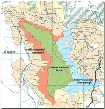
Map, INRENA
In a press release issued by INRENA on January 15, of this year, INRENA states that conserving these areas is of fundamental importance in order to guarantee soil and watershed integrity. They go on to say that it is necessary to protect the exceptional landscape beauty, the unique geologic formations, and the endangered wildlife of the area (1). For these reasons, many national and international environmental organizations worked until the areas received formal protection.
Coordination to establish these new protected areas began in 1994, during a series of talks between the Center for Indigenous Amazonian Development (CEDIA) and the Association for Conservation of Cutivireni Heritage (ACPC) and indigenous communities in the area. The communities felt that their resources were threatened by river contamination, deforestation, highway construction, and new colonists clearing the land to establish agriculture and ranching. These concerns brought indigenous organizations, like Central Asháninka of Tambo River (CART), Central Asháninka of Ene River (CARE), Asháninka Organization of Apurímac River (OARA) and the Machiguenga Confederation of the Urubamba (COMARU), together with CEDIA and ACPC to conserve the natural resources and start the process to title the land in such a way that they would benefit.
In 1999, Conservation International allied with the above mentioned institutions and started the Global Environment Facility (GEF) in Vilcabamba, with financial support from the World Bank. After several years of negotiations and discussing various points of view, CEDIA, ACPC, the Regional Association of Indigenous Pueblos (ARPI), the Bien Común Institute and INRENA, decided to support a project to create two communal reserves and one national park in October of 2002. Three months later, the project was finally approved.
Otishi\’s Magic
Otishi National Park is located in the upper elevations of the Vilcabamba Range, between the Tambo River district, Province of Satipo (Department of Junín) and the district of Echarate, Province of La Convención (Department of Cuzco). There are various life zones in the region: Moist premontane tropical forest, premontane tropical rainforest, lower montane tropical rainforest, lower montane subtropical rainforest, montane tropical rainforest, and montane subtropical rainforest. The technical report titled, Categorization of the Vilcabamba Reserved Zone regarding Otishi National Park of October 2002, included information previously collected by Conservation International\’s Rapid Biological Evaluation (RAP). Conservation International had research two of the highest points of the mountain range; one was at the headwaters of Pomureni River (tributary of the Ene River) and the other at the headwaters of the Poyeni River (tributary of Tambo River). According to the technical report, which quoted Conservation International, there are primarily three vegetation types at 3350 meters above sea level: (1) pajonales, which are herbaceous meadows with scattered low shrubs, (2) Polylepis forest, which is pale green forest dominated by one or two species of Polylepis, and (3) mixed species of montane forest, which are dark green, stunted to moderately tall species.
Of these three vegetation types, the Polylepis forests, also known as queñual forests, are of great importance. The species is native to the Andes of Peru and Ecuador and grows to a height of 4 to 5 meters on limestone substrate. The \”queñual\” is a threatened species as it is affected by burning of nearby pastures and is used as timber and firewood. Forests with this species are found in the regions of Ancash, Junín, Lima, Cuzco, Apurímac, Ayacucho, Huancavelica and Cajamarca. One of the reasons for creating Otishi National Park was to protect the large extensions of Polylepis forests in Vilcabamba.
Conservation International\’s scientific expedition to Otishi National Park found three new mammal species at 2050 meters above sea level: two Murida rodents, and on mouse of the Abrocomida family. Among the anurous and reptiles, 12 of 16 species found were new to science. Among those, include a new species of Proctoporus (lizard) and two new Phrynopus (toads), two endemic genuses to the Andes. Several new insects were also discovered: of 28 butterflies collected at 3350 meters above sea level, 9 species and 4 subspecies were new to science. \r\n\r\n
The Machiguenga, Ashaninka, Kakinte and Yine
Engineer Ricardo Risco, Coordinator of Lower Urubamba Projects for the Center for Amazonian Indigenous Development (CEDIA), explained that once the Machiguenga Communal Reserve, Ashaninka Communal Reserve, and Otishi National Park were declared, the project entered a new stage. He said that after this declaration, the second stage, social management, began. He explains that the native communities of the Machiguengas, Ashaninkas, Kakinte and Yine should receive training and environmental education workshops to better manage their natural resources using a sustainable development model. People should be organized, attend their meetings, and work with them. He also says that unfortunately, this process has been halted at the concept stage. There is no economic support for this part, which is even more important. We must therefore wait for the finances necessary to give this process a boost and have the possibility of reaching these people.
Lack of economic resources means that the project cannot continue. Designing programs that benefit the rural communities is something that remains pending with INRENA. The proposed work agenda that CEDIA developed with INRENA has also reached a screeching halt. We hope that another 40 years does not go by before these protected areas move from their status as \”paper parks\” into functioning protected areas that reach their stated objectives.
ParksWatch-Peru is currently conducting a field evaluation of the area. We will have the results of the evaluation available on our website soon.
ParksWatch-Perú: December, 2003
By: Inés Vera
__________
Notes:
1 Press Release, Instituto Nacional de Recursos Naturales, INRENA. Lima, January 15, 2003.