Concerned with reports of deforestation and poaching in the southeastern corner of Laguna del Tigre National Park, ParksWatch-Guatemala conducted a preliminary assessment of the threats caused by human activity in the areas surrounding the community of Paso Caballos and the archeological site El Perú. The investigation uncovered several significant threats to the region, including rapid deforestation around Paso Caballos (by law a \”Special Use Zone\” where some agriculture is legal) and poaching of scarlet macaws chicks (Ara macao) in the forests around El Perú. With active oil wells, roads, and 13 settlements within park borders, Laguna del Tigre is severely threatened throughout, and ParksWatch is currently conducting a full evaluation of the entire park. The following report summarizes the results of our preliminary investigation of the park\’s southeastern section.
Laguna del Tigre: Central America\’s largest freshwater wetland wilderness
Laguna del Tigre occupies the northwestern section of the 1.6 million hectare Maya Biosphere Reserve (MBR) in the department of Petén, and is bordered by Mexico to the north and west, the San Pedro River and the buffer zone of the MBR to the south, and the MBR\’s multiple use zone to the east. Guatemala\’s largest national park, it encompasses close to 300,000 hectares of wetlands and tropical moist forest. In addition to containing critical habitat for migratory birds, the park supports populations of several endangered and culturally important animals including jaguars (Panthera onca), pumas (Puma concolor), scarlet macaws, harpy eagles (Harpia harpyja), and the regionally endemic crocodilian Crocodylus moreletti.
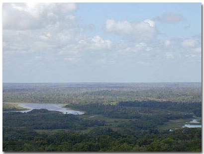
Wetlands and tropical forest of Laguna del Tigre National Park as seen from El Perú archeological site.
Paso Caballos:
A Special Use Zone
Located inside the southeast corner of the park, the community of Paso Caballos surrounds the natural springs that are the source of the San Pedro River. Because of this water supply, the area has been used sporadically throughout the past century as a base camp for chicle collectors. (Chicle is the latex used as the natural base for chewing gum, which is extracted from the Chicozapote tree (Manilkara zapota).) When the current inhabitants began arriving in the early 1990\’s, via a 16-kilometer trail through the forest, the area had been abandoned for several years, and was already officially declared a national park. Despite its protected status, the people were allowed to stay, and a 1999 agreement with CONAP-Guatemala\’s agency in charge of protected areas-gave Paso Caballos legal status as one of the park\’s \”Special Use Zones.\” As part of this agreement the community was allotted 6,350 hectares of park land to use under a management plan drafted and enforced by CONAP. Each family received a 45-hectare parcel of forest to use, under the condition that they would not clear their entire parcel and would prevent any new arrivals from settling in the area. In addition, the agreement included construction of a road connecting the community to the network of roads in the MBR\’s buffer zone. The road was completed in June 1999, and despite being impassable during much of the rainy season, it has vastly facilitated access to the community and the surrounding park.
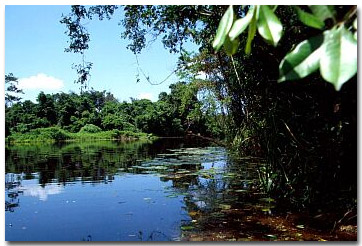
San Pedro River near the community of Paso Caballos.
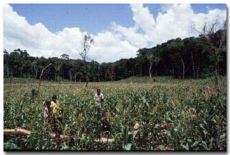
Maize field within the Paso Caballos \”Special Use Zone.\”
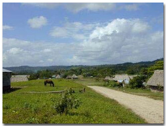
The entrance to Paso Caballos a \”Special Use Zone\” of Laguna del Tigre National Park.
According to several sources, the road has allowed more people to enter Paso Caballos and settle the surrounding forest. When asked about new people moving into the park, one settler told ParksWatch that the community continues to grow without control. This occurs even though CONAP has a guard station on the new road just a few kilometers outside the community. Interviews with locals point out that even though local conservation NGO ProPetén and CONAP are working with the community to instill an environmental ethic and slow deforestation, the agricultural mentality continues to be deeply rooted. Exacerbating the problem is the community\’s extremely high birth rate. ParksWatch visited the community in 1999 and again in 2000, and the rate of deforestation is not slowing. It does not bode well for the future of the forests surrounding this Special Use Zone that the community is growing rapidly-from both high birth rates and new arrivals-and that at this point it remains totally dependent on maize for both subsistence and as a cash crop.
El Perú
The archeological site El Perú is located 15 kilometers downstream from Paso Caballos to the west. It is a one-hour trip by motorboat followed by a 40-minute walk through the forest to arrive at the control station of Guatemala\’s Institute of Anthropology and History (IDAEH). The station is staffed by 3 IDAEH guards who are responsible for protecting the Mayan ruins and the surrounding forest from looting, poaching, and other human disturbance. ProPetén has a significant presence in the area as well, as part of their program to protect nesting sites of scarlet macaws throughout the MBR.
ProPetén maintains a biological station called Las Guacamays (The Scarlet macaws), which is located between Paso Caballos and El Perú on the banks of the San Pedro River. ProPetén rangers explained to ParksWatch how groups of armed men enter El Perú to rob the macaw nests and then sell the chicks as pets. Unfortunately, not even the combined efforts of IDAEH, ProPetén and CONAP-which maintains a guard station in the area-are enough to protect the chicks. According to IDAH rangers, last year only five eggs hatched, of which two were stolen and a third was lost to an attack of a predatory bird. Another threat to the macaws is the invasion of the exotic African bee (Apis spp). This bee invades the nests and prevents the macaws from reproducing.
Along with poaching, looting of archeological sites also occurs, although IDAEH workers assured us that during the past two years it has not been a significant problem. Overall, the area around El Perú is well-protected, much to the credit of the three IDAEH guards that work 22-day shifts for extremely low wages. According to these men, they do not have enough staff to patrol the entire area. Adding to this sentiment, ProPetén guards told ParksWatch that human encroachment from the park\’s Special Use Zones, as well as from settlements outside the park, is impossible to monitor with the current number of park guards. Increasingly hunters are being found deep within the park, well outside the Special Use Zones.
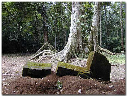
A stelae that has been cut by a chainsaw to remove its intricate carvings. This particular incident of
looting probably occurred several years ago.
The Future of Laguna del Tigre: macaws or maize?
The existence of human inhabitants in one of Central America\’s most important protected areas demands that vigilance and protection in the areas surrounding the Special Use Zones be one of the highest conservation priorities for the government. Aggressive community involvement in Paso Caballos and other Special Use Zones is necessary. Agricultural reform and alternative employment opportunities are needed to steer farmers away from their dependence on maize as a cash crop. One idea is to employ people from Paso Caballos at ProPetén\’s biological station, which currently does not employ any local people despite being located just 5 kilometers from the community. Only with strict protection of all areas outside the Special Use Zones and aggressive involvement within them, can the forests and wetlands of Laguna del Tigre be saved. ParksWatch is currently conducting a full evaluation of the conservation status of the park.
(Top image: map of the Maya Biosphere Reserve showing the location of Paso Caballos and El Perú)
ParksWatch: December 2001